The Distance to the Sea Horizon at Altitude calculator computes the distance to the horizon from a specified height using a spherical model the mean spherical radius of the Earth.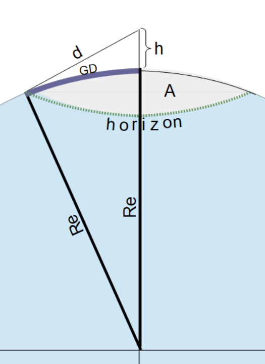
INSTRUCTION: Choose units and enter the following:
- (h) Altitude above Sea Level
Distance to Horizon (d): The calculator returns the distance to the horizon in kilometers. The calculator also returns the following:
- (d) Distance to Horizon in kilometers.
- (GD) Ground Distance along the arc in kilometers. Note: this is very close to d in an Earth model until high altitudes.
- (A) Area of Observation on the orb in square kilometers.
All the above can be automatically converted to compatible units via the pull-down menu.
The Math / Science
The formula for the distance to the horizon is:
`d = sqrt(h*(2*Re + h))`
where:
- d is the distance to the horizon
- Re is the mean equatorial radius of the Earth
- h is the height above the Earth's surface
The Area of Observation (A) is defined as the theoretical limit of area one could see at height h above the orb, Earth in this case. The formula for Area of Observation is:
A = π ⋅ GD2
where:
- A = Area of Observation
- GD = Ground Distance (see graphic)
The formula for Ground Distance is:
GD = acos(R/(R+h)) * R
where:
- GD = Ground Distance
- h = height above the orb
- R = radius of the orb (Mean Earth Radius in this calculator)
Derivation
The graphic shows a right triangle, which is formed when looking to the horizon at any elevation (h). The sides of the right triangle are:
- d - the distance to the horizon
- h + Re - the distance from the observation point to the center of the Earth
- Re - the radius of the Earth at the horizon point.
Using the Pythagorean theorem, we know:
d2 + Re2 = (h + Re)2
Now we can use simple algebra to isolate the distance to the horizon (d).
- Expand the right hand side: d2 + Re2 = h2 + 2•h•Re + Re2
- Subtract Re2 from both sides: d2 = h2 + 2•h•Re
- Factor h out of the right side: d2 = h•(h+2•Re)
- Take the square root of both sides to get:
`d = sqrt(h*(h+2*Re))`
Unfortunately the Earth is not a perfect sphere. It has mountains and valley, but it also had a bulge around the Equator. This bulge makes Earth more of an Oblate Spheroid that is the shape one gets when rotating an ellipse about an axis. In the Earth's case, the ellipse is rotated around the polar axis (see diagram).
For this reason, this distance to the horizon equation is only an approximation. Better models would take into account the changes in terrain and Earth's oblateness.
Earth Model Calculators
- Slant Range using Position Vectors
- Slant Range from Elevation Angle (α)
- Slant Range using Subtended Angle (β)
- Distance to Horizon
- Angle of Satellite Visibility
- Grazing Angle
- XYZ to Latitude, Longitude, Altitude
- Earth WGS-84 Equatorial radius in meters: 6378137.0 m
- Earth WGS-84 Polar radius in meters: 6356752.31424518 m
- Earth Flattening Factor (WGS-84): 0.00335281066474748071984552861852
- Ellipse flattening factor: F = (Er - Pr)/Er
- Geocentric to Geodetic Latitude
- Geodetic to Geocentric Latitude
Navigation Calculators:
- Haversine Distance (decimal degrees): Compute the Distance Between two Points on the Earth (Great Circle Arc)
- Haversine Distance (Degrees, Minutes and Seconds): Compute the Distance Between two Points on a Sphere (Great Circle Arc) using degrees, minutes and seconds verses decimal degrees.
- Rhumb Line Azimuth: Computes the azimuth heading one can navigate for a path that crosses all meridians of longitude at a constant angle.
- Rhumb Line Distance: Computes the distance traveled between two points on the globe if traveled via a rhumb line.
- Travel Time between Coordinates: Compute the time to travel between two location (latitudes and longitudes) based on a average speed.
- Navigation Speed: Computes the required average speed needed to go between coordinates on a great circle arc within a given amount of time.
- Distance to Sea Level Horizon: Computes the distance to the sea horizon at an altitude
- Correction Angle: navigation equation that compensates for air or water currents.
- Distance to Sea Level Horizon: Compute the distance to the horizon based on a height above the orb using a spherical Earth model.
- Decimal Degrees: Compute decimal degree angles from degrees, minutes and seconds,[CLICK HERE].